
Welcome to 284 Media’s live coverage of Tropical Storm Ernesto. This article will provide real-time updates on the storm’s development. As well as important advisories issued for the Territory.
We’ll be closely monitoring advisories from the National Hurricane Center (NHC) and Department of Disaster Management (DDM), and updating this article with the latest information.
4:20 PM Wednesday 14 August
Governor Daniel Pruce has issued an “All Clear” for the territory following the passage of Hurricane Ernesto, signaling that the immediate threat has subsided.
2:00 PM Wednesday 14 August Update
Tropical Storm Warning Discontinued for the British Virgin Islands.
The Tropical Storm Warnings for Puerto Rico and the U.S. Virgin Islands have been discontinued.
There are no coastal watches or warnings in effect. Interests in Bermuda should monitor the progress of Ernesto. A hurricane watch may be required for the island later today.
On the forecast track, the center of Ernesto will continue to move away from Puerto Rico today, move across the western Atlantic during the next few days, and approach Bermuda Friday and Saturday.
𝙁𝙇𝘼𝙎𝙃 𝙁𝙇𝙊𝙊𝘿 𝙒𝘼𝙍𝙉𝙄𝙉𝙂 𝙀𝙓𝙏𝙀𝙉𝘿𝙀𝘿
A FLASH FLOOD WARNING IS IN EFFECT FOR LOW LYING AND FLOOD PRONE AREAS OF THE BRITISH VIRGIN ISLANDS VALID UNTIL 4 PM TODAY WEDNESDAY. A FLASH FLOOD WARNING MEANS THAT MODERATE TO MAJOR FLOODING IS OCCURRING OR IMMINENT IN THE WARNING AREA. FLASH FLOODING IS A VERY DANGEROUS SITUATION.
DO NOT ATTEMPT TO CROSS SWIFTLY FLOWING WATERS OR WATERS OF UNKNOWN DEPTH BY FOOT OR BY VEHICLE. NOTE, JUST ONE FOOT OF FLOWING WATER IS COULD BE ENOUGH TO SWEEP A CAR OFF THE ROAD.
Midday Wednesday 14 August Update
ERNESTO BECOMES A HURRICANE NORTH OF PUERTO RICO
SIGNIFICANT FLOODING LIKELY ACROSS PUERTO RICO AND THE VIRGIN
ISLANDS AS HEAVY RAINS PERSIST
LOCATION…20.5N 67.6W ABOUT 175 MI…280 KM NW OF SAN JUAN PUERTO RICO ABOUT 835 MI…1340 KM SSW OF BERMUDA MAXIMUM SUSTAINED WINDS…75 MPH…120 KM/H PRESENT MOVEMENT…NW OR 310 DEGREES AT 16 MPH…26 KM/H MINIMUM CENTRAL PRESSURE…991 MB…29.27 INCHES
Data from Air Force Reserve and NOAA Hurricane Hunter aircraft indicate that maximum sustained winds have increased to near 75 mph (120 km/h) with higher gusts. Additional strengthening is forecast during the next couple of days.
Hurricane-force winds extend outward up to 35 miles (55 km) from the center and tropical-storm-force winds extend outward up to 230 miles (370 km).
7:30 AM Wednesday 14 August Update
The Department of Disaster Management has issued an advisory urging residents to stay off the roads as the all-clear has not yet been given.
Assessment teams are currently evaluating the situation and will begin clearing the main roads first.
The department asks for the public’s patience, emphasizing that the safety of the teams is also a top priority.
11 PM Tuesday 13 August UPDATE
SUMMARY OF 1100 PM AST…0300 UTC…INFORMATION
LOCATION…18.8N 65.3W ABOUT 35 MI…55 KM NW OF ST. THOMAS ABOUT 60 MI…95 KM ENE OF SAN JUAN PUERTO RICO MAXIMUM SUSTAINED WINDS…65 MPH…100 KM/H PRESENT MOVEMENT…NW OR 305 DEGREES AT 17 MPH…28 KM/H MINIMUM CENTRAL PRESSURE…998 MB…29.47 INCHES
9 PM Tuesday 13 August UPDATE
Our news desk has received reports of widespread power outages affecting multiple areas throughout the Territory. The outages have been attributed to Tropical Storm Ernesto, which is currently passing over the region.
In addition to the power disruptions, there are also reports of downed poles and fallen trees in various locations currently being battered by strong winds.
Downed power lines can be reported to BVIEC at 284 852 4600.
Residents are strongly urged to remain indoors and avoid unnecessary travel as the storm continues to impact the Territory.
More updates will be provided as they become available.
8 PM Tuesday 13 August UPDATE
ERNESTO MOVING OVER THE VIRGIN ISLANDS
EXPECTED TO BECOME A HURRICANE OVERNIGHT WHILE PASSING NORTHEAST OF PUERTO RICO
LOCATION…18.4N 64.7W ABOUT 20 MI…30 KM E OF ST. THOMAS ABOUT 90 MI…145 KM E OF SAN JUAN PUERTO RICO MAXIMUM SUSTAINED WINDS…65 MPH…100 KM/H PRESENT MOVEMENT…WNW OR 300 DEGREES AT 18 MPH…30 KM/H MINIMUM CENTRAL PRESSURE…998 MB…29.47 INCHES.
Aircraft data indicate that maximum sustained winds have increased to near 65 mph (100 km/h) with higher gusts. Strengthening is forecast during the next several days. Ernesto is expected to become a hurricane later tonight or early Wednesday to the north of the Virgin Islands and Puerto Rico.
Tropical-storm-force winds extend outward up to 115 miles (185 km) from the center. A National Ocean Service station in Charlotte Amalie, St. Thomas, recently reported a wind gust of 43 mph (69 km/h).
The estimated minimum central pressure is 998 mb (29.47 inches) based on Hurricane Hunter aircraft data.
5:00 PM – Tuesday 13 August Update
ERNESTO HEADING TOWARD THE VIRGIN ISLANDS
EXPECTED TO BECOME A HURRICANE TONIGHT WHILE PASSING NORTHEAST OF PUERTO RICO
SUMMARY OF 500 PM AST…2100 UTC…INFORMATION
LOCATION…18.0N 64.1W ABOUT 65 MI…105 KM ESE OF ST. THOMAS ABOUT 135 MI…215 KM ESE OF SAN JUAN PUERTO RICO MAXIMUM SUSTAINED WINDS…60 MPH…95 KM/H PRESENT MOVEMENT…WNW OR 300 DEGREES AT 18 MPH…30 KM/H MINIMUM CENTRAL PRESSURE…1001 MB…29.56 INCHES
CHANGES WITH THIS ADVISORY:
The government of Antigua and Barbuda has discontinued the Tropical
Storm Warning for Montserrat.
SUMMARY OF WATCHES AND WARNINGS IN EFFECT:
A Hurricane Watch is in effect for…
* U.S. Virgin Islands * British Virgin Islands * Vieques and Culebra
A Tropical Storm Warning is in effect for…
* St. Kitts, Nevis, and Anguilla * St. Martin and St. Barthelemy * Sint Maarten * Saba and Sint Eustatius * British Virgin Islands * U.S. Virgin Islands * Puerto Rico * Vieques and Culebra
Interests in Bermuda should monitor the progress of Ernesto.
At 500 PM AST (2100 UTC), the center of Tropical Storm Ernesto was located near latitude 18.0 North, longitude 64.1 West. Ernesto is moving toward the west-northwest near 18 mph (30 km/h). A turn toward the northwest with a gradual decrease in forward speed is expected tonight, followed by a turn toward the north-northwest and north Wednesday night and Thursday.
On the forecast track, the center of Ernesto should pass near or over the Virgin Islands this evening, and then pass just to the northeast and north of Puerto Rico tonight and on Wednesday. Ernesto should then move over the western Atlantic later in the week and be near Bermuda by Friday.
Data from an Air Force Reserve Hurricane Hunter aircraft indicate that maximum sustained winds are near 60 mph (95 km/h) with higher gusts. Strengthening is forecast, and Ernesto is expected to become a hurricane by tonight to the north of the Virgin Islands and Puerto Rico.
Tropical-storm-force winds extend outward up to 115 miles (185 km) from the center. A wind gust of 54 mph (87 km/h) was recently reported at St. Martin.
The estimated minimum central pressure is 1001 mb (29.56 inches).
2:00 PM – Tuesday 13 August Update
AIR FORCE RESERVE HURRICANE HUNTERS FIND ERNESTO STILL STRENGTHENING
TROPICAL STORM CONDITIONS EXPECTED TO BEGIN IN THE VIRGIN ISLANDS IN A FEW HOURS
SUMMARY OF 200 PM AST
LOCATION…17.5N 63.5W ABOUT 85 MI…140 KM E OF ST. CROIX ABOUT 175 MI…285 KM ESE OF SAN JUAN PUERTO RICO MAXIMUM SUSTAINED WINDS…60 MPH…95 KM/H PRESENT MOVEMENT…WNW OR 295 DEGREES AT 18 MPH…30 KM/H MINIMUM CENTRAL PRESSURE…1003 MB…29.62 INCHES
CHANGES WITH THIS ADVISORY:
The government of Antigua and Barbuda has discontinued the Tropical Storm Warning for Antigua and Barbuda.
The government of France has discontinued the Tropical Storm Warning for Guadeloupe.
SUMMARY OF WATCHES AND WARNINGS IN EFFECT:
A Hurricane Watch is in effect for…
* U.S. Virgin Islands * British Virgin Islands * Vieques and Culebra
A Tropical Storm Warning is in effect for…
* St. Kitts, Nevis, Montserrat, and Anguilla * St. Martin and St. Barthelemy * Sint Maarten * Saba and Sint Eustatius * Puerto Rico * Vieques and Culebra
On the forecast track, the center of Ernesto should pass near or over the Virgin Islands this evening, and then pass just to the northeast and north of Puerto Rico tonight and on Wednesday. Ernesto should then move over the western Atlantic later in the week.
Data from an Air Force Reserve Hurricane Hunter aircraft indicate that maximum sustained winds have increased to near 60 mph (95 km/h) with higher gusts. Additional strengthening is forecast, and Ernesto is expected to become a hurricane by early Wednesday.
Tropical-storm-force winds extend outward up to 105 miles (165 km) from the center. A wind gust of 62 mph (100 km/h) was recently reported at Gustavia, St. Barthelemy.
1:30 PM – Tuesday 13 August Update
NEOC ACTIVATED AT LEVEL 1
Governor Daniel Pruce has activated the National Emergency Operations Centre at Level 1, which is a monitoring phase.
The Department of Disaster Management has advised that residents should rush to complete storm preparations by this afternoon and prepare to remain in a safe space tonight and tomorrow as the storm passes.
11:30 AM – Tuesday 13 August Update
FLASH FLOOD WATCH ISSUED FOR THE VIRGIN ISLANDS
A flash flood watch is in effect for low lying and flood prone areas of the leeward islands until midnight tonight and for the British Virgin Islands until midday tomorrow.
A flash flood watch means that moderate to major flooding is possible but not imminent in the watch area. Flash flooding is a very dangerous situation.
Spiral bands associated with Tropical Storm Ernesto could still bring heavy rainfall between 2 and 4 inches over the leeward islands; For the BVI between 3 to 6 inches. Hence, moderate to major flooding of low lying and flood prone areas is possible.
11:00 AM – Tuesday 13 August Update
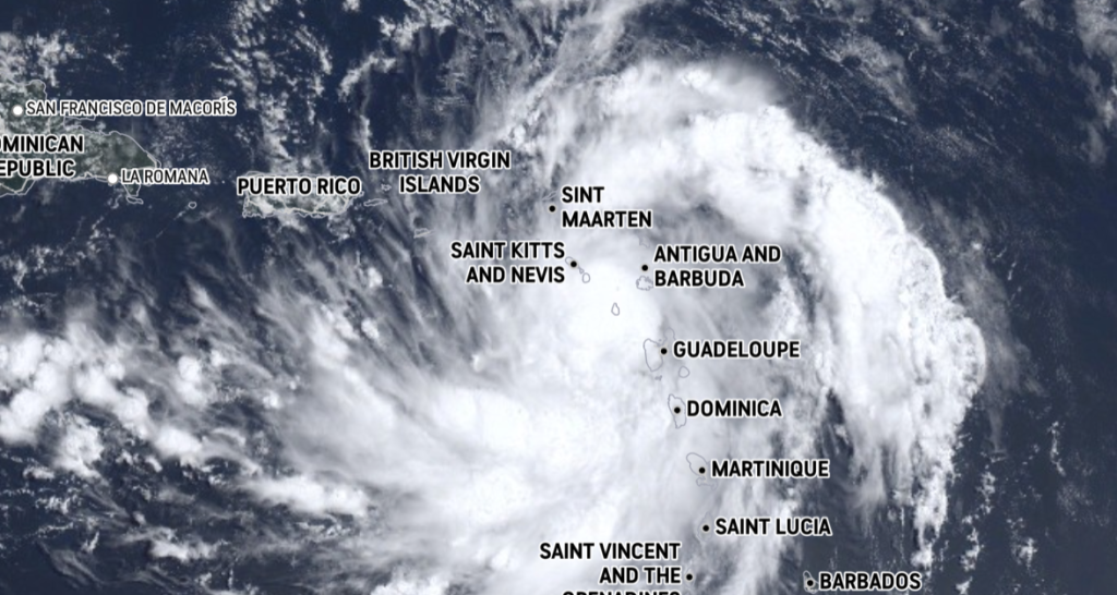
ERNESTO A LITTLE STRONGER AS IT PASSES JUST SOUTH OF ST. KITTS AND NEVIS
HURRICANE WATCH ISSUED FOR THE VIRGIN ISLANDS, VIEQUES, AND CULEBRA
LOCATION…16.9N 62.6W ABOUT 155 MI…250 KM ESE OF ST. CROIX ABOUT 250 MI…405 KM ESE OF SAN JUAN PUERTO RICO MAXIMUM SUSTAINED WINDS…50 MPH…85 KM/H PRESENT MOVEMENT…WNW OR 290 DEGREES AT 18 MPH…30 KM/H MINIMUM CENTRAL PRESSURE…1003 MB…29.62 INCHES
CHANGES WITH THIS ADVISORY: A Hurricane Watch has been issued for the U.S. Virgin Islands, Culebra, and Vieques. The government of Antigua and Barbuda has issued a Hurricane Watch for the British Virgin Islands. A Hurricane Watch means that hurricane conditions are possible within the watch area, in this case within the next 12 hours or so.
SUMMARY OF WATCHES AND WARNINGS IN EFFECT: A Hurricane Watch is in effect for…
*U.S. Virgin Islands * British Virgin Islands * Vieques and Culebra A Tropical Storm Warning is in effect for… * St. Kitts, Nevis, Montserrat, Antigua, Barbuda, and Anguilla * Guadeloupe * St. Martin and St. Barthelemy * Sint Maarten * British Virgin Islands * U.S. Virgin Islands * Puerto Rico * Vieques and Culebra.
On the forecast track, the center of Ernesto should pass near or over the Virgin Islands this evening, and then pass just to the northeast and north of Puerto Rico tonight and on Wednesday.
Ernesto should then move over the western Atlantic later in the week. Maximum sustained winds have increased to near 50 mph (85 km/h) with higher gusts.
Additional strengthening is forecast, and Ernesto is expected to become a hurricane by early Wednesday. Tropical-storm-force winds extend outward up to 105 miles (165 km) from the center. A wind gust to 65 mph (105 km/h) was recently reported on St. Barthelemy.