
The National Hurricane Center is closely watching several areas of disturbed weather in the Atlantic basin as the peak of hurricane season is underway.
In its latest Tropical Weather Outlook, the NHC reported that it is monitoring two areas of interest in the central and eastern tropical Atlantic.
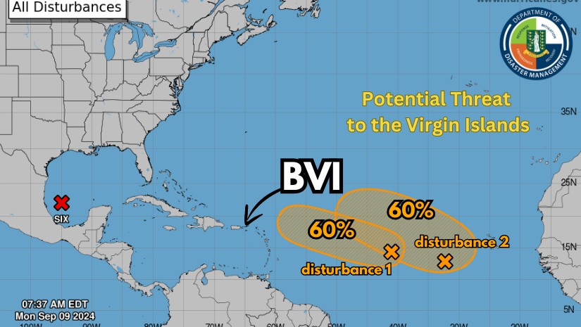
An area of low pressure in the central tropical Atlantic is producing disorganized showers and thunderstorms. Environmental conditions are considered marginally conducive for further development over the next few days as the system moves westward-northwestward at around 10 mph. The NHC estimates a 60% chance of formation through the next seven days.
Further east, a trough of low-pressure west-southwest of the Cabo Verde Islands is also generating disorganized shower and thunderstorm activity. The NHC believes this system could gradually develop into a tropical depression later this week as it moves west-northwestward at 10-15 mph, placing its seven-day formation chances at 60%.
Following dire forecasts for an above-normal Atlantic hurricane season, conditions in the region have grown eerily calm in recent weeks, defying expectations.
According to a new report from researchers at Colorado State University, the last time the Atlantic went this long without producing any named storms between August 13 and September 3 was over 50 years ago, in 1968.
This unusual lull comes after officials warned of an 85% chance of above-normal Atlantic hurricane activity, with as many as 25 named storms predicted for the season.
So far, there have been five named storms, three of which strengthened into destructive hurricanes: Beryl, Debby, and Ernesto. But the hurricane season typically peaks between August and October, leading experts to caution that it’s too soon to consider the season a wrap.